
 Area: 20,273 km2
Length of state border: 1,370km (Croatia 670km, Austria 318km, Italy 280 km and Hungary 102km)
Length of coastline: 46.6km
Landscape: In Slovenia four great European landforms meet: the Alps in the North of the country, the Dinarides in the South, Mediterranean landforms in the South-West, and the Pannonian Basin in the East. 63.3% of Slovenia is forested; 30.5% is under cultivation, and 2.8% of Slovenia is urban.
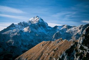
Highest peak: Triglav: 2,864m
Average height above sea level: 556.8m
Longest river: Sava, 221km
The largest karst cave system: Postojnska jama, length 20.579m
Lakes: The largest is the intermittent Cerkniško jezero (24km2); the deepest lake is Bohinjsko jezero (45m).
Highest waterfall: Čedca (130m)
Climate: continental in central Slovenia, Alpine in the North-West, and sub-Mediterranean in the coastal region
Mean temperature: January: -2ºC; July: 21ºC


